Rising sea levels
Sea levels have been rising since the early 1900s. The rate is accelerating, doubling approximately every 10 years. The initial rise was due primarily to thermal expansion as the seas warmed. Today, glaciers and ice-caps are melting, decanting into the ocean faster than at any time in the last 10,000 years. NIWA currently estimates a rise in sea levels up to 2m by 2100. It will rise at least 30cm before 2050, a rate that is ‘locked in’, ie it will happen regardless of what actions we take (see video below) because of lag between the amount of CO2 already in the atmosphere and the effect on rising temperatures.
When ice caps have melted in the past, sea levels have abruptly jumped as much as 2m in 50 years, so the minimum rate may need to be revised upwards as the rate that ice shelves holding back glaciers and ice caps in Greenland and the Antarctic collapse (see for example the Thwaites glacier).
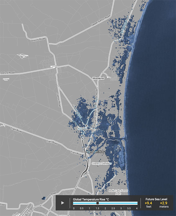
As seas rise, river mouths migrate inland as the land is inundated. Because braided rivers mouths form complex estuaries and hapua, the morphology of these areas will undergo physical re-arrangement as they move inland. In some places estuaries will become harbours and hapua will become estuaries, the locations of which will vary or vanish altogether depending on landform, land use, and flood control measures used by local and regional governments to prevent inundation and the loss of critical infrastructure.
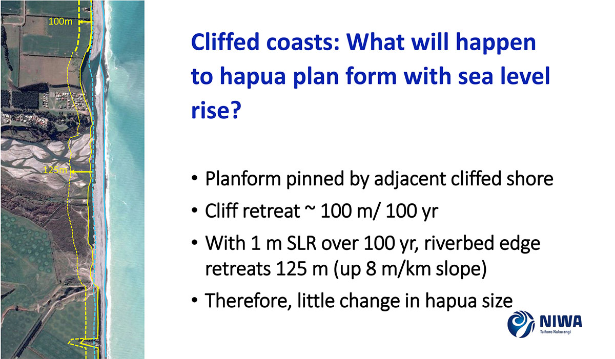
Where river-mouths can freely retreat inland and there is sufficient gravel, new hapau will readily form (or retreat) in low-lying areas behind historic and extant dune systems (see the NIWA slide below).
Why is it a problem for braided rivers?
- Short term – saltwater influx into existing brackish or freshwater hapua, leading to degradation of existing ecology
- Mid-term – increasing frequency of inundation leading to permanent inundation of existing hapua (see Table 3.2 below)
- Progressive – coastal squeeze in some areas will prevent the natural inland migration of estuaries and hapua, with flood control measures built or reinforced to protect existing land, built structures and critical infrastructure. Hapua and lagoons will disappear in these circumstances, reducing the habits of species dependent upon them.
- See discussion in relation to the Ashley estuary
Research and references
The New Zealand Coastal Policy statement is 9 years old and based research and knowledge that has since been superseded. Because the impact of rising sea levels on cities and infrastructure is so critical, research, plans, and policies are moving at a very fast pace. Below are references to material specifically used in this page or are direct relevance. If you are interested in this topic, for the latest information | we recommend Climate Central or the journal Nature Climate Change.
- 2019: Paulik et al (NIWA); Coastal Flooding Exposure Under Future Sea-level Rise for New Zealand | National Science Challenges |
- 2019: (IPCC) Intergovernmental Panel on Climate Change’s special report on the oceans and cryosphere
- 2019: Hicks (NIWA): Rising sea-level impacts on braided river mouths (hapua). Braided Rivers 2019 Seminar
-
2019: Sutherland et al; Direct observations of submarine melt and subsurface geometry at a tidewater glacier; Science 26 Jul 2019: Vol. 365, Issue 6451, pp. 369-374 (ie, Alaskan glaciers meting faster than previously thought)
- 2019: Dangendorf et al; Persistent acceleration in global sea-level rise since the 1960s; Nature Climate Change volume 9, pages 705–710 (2019)
-
2019: Milillo et al; Heterogeneous retreat and ice melt of Thwaites Glacier, West Antarctica; Science Advances 2019 Jan; 5(1): eaau3433
-
2019: Mouginot et al; Forty-six years of Greenland Ice Sheet mass balance from 1972 to 2018;
- 2018: (IPCC) Church et al; Sea Level Change. In: Climate Change 2013: The Physical Science Basis. Contribution of Working Group I to the Fifth Assessment Report of the Intergovernmental Panel on Climate Change
-
2016: Hansen et al; Ice melt, sea-level rise and superstorms: evidence from paleoclimate data, climate modelling, and modern observations that 2 ◦C global warming could be dangerous. Atmos. Chem. Phys., 16, 3761–3812, 2016
-
2015: Whitelaw; Where will estuaries be allowed to go?
-
2015: Parliamentary Commissioner for the Environment: preparing New Zealand for rising seas
-
2012: Deschamps et al; Ice-sheet collapse and sea-level rise at the Bølling warming 14,600 years ago; Nature volume 483, pages 559–564 (29 March 2012)
-
2011: Whitelaw; The Vulnerability of Tuhaitara Coastal Park to Rising Sea-levels
-
NIWA: Sea level rise Avon-Heathcote Estuary (case model relevant to Canterbury)