Hurunui River
The Hurunui River is one of the most diverse rivers in Canterbury. It has two main branches, each with distinctive attributes originating east of the Main Divide in New Zealand’s Southern Alps. Some 150km long, the total catchment area (click to see interactive map) of the river is 2671 km2.
The source of the north branch of the Hurunui is predominantly Lake Sumner, a remote high country lake. The south branch originates in the Southern Alps at Harpers Pass, with hot springs nearby. Some of the tributaries include the Jollie Brook, the Glenrae River and the Mandamus River.
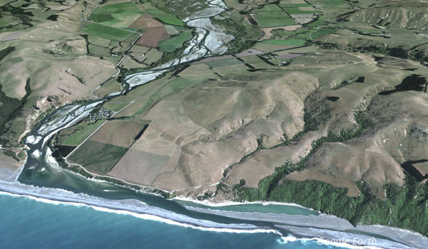
Once past the foothills, the Hurunui River flows out onto the Canterbury Plains and through the Culverden basin until it reaches the coast just a few kilometres south of Port Robinson. Like most of Canterbury’s braided rivers, because of its sporadic flow regime and high sediment load, it forms a ‘braided’ estuary/lagoon-hapua system as it enters the Pacific.
Biodiversity & Cultural Significance
>Important Bird Areas on the Hurunui River: links to 7-page PDF file that includes maps, habitat types, and threats relevant to the larger Rakaia catchment. This document was extracted from Forest & Bird’s 177-page 20Mb file on all rivers, lakes, and coastal areas.
Extract from the Hurunui and Waiau Regional Plan:
The takiwā (geographical interests) of two Ngāi Tahu Hapū (sub tribes) straddle the Hurunui and Waiau river catchments: Ngāti Kuri and Ngāi Tuahuriri. Ngāti Kuri’s interest extends from Parinui o Whiti (White Bluffs) in the north to the Hurunui River in the south, east from the Main Divide out to sea as far as the eye can see. Ngāi Tuahuriri’s interest extends from the Hurunui River in the north to the Hakatere/Ashburton River in the south, east from the main divide and out to sea as far as the eye can see.
The mauri of the Waiau and Hurunui rivers represents the essence that binds the physical and spiritual elements of all things together, generating and upholding all life. All elements of the natural environment possess a life force, and all forms of life are related. Mauri is therefore a critical element of the spiritual relationship of Ngāi Tahu whānui with the rivers.
The Hurunui River once provided an important mahiā kai resource for Ngāi Tahu. Traditionally, the river was particularly known for its tuna (eel) and inaka (whitebait). Nohoanga (settlements) were located at points along the length of the Hurunui river, with some wāhi tapu located near the mouth. There is a statutory acknowledgement on both the Hurunui River and Hoka Kura (Lake Sumner).
For Ngāti Kuri the Waiau-uha (the Waiau River) is connected through whakapapa to Waiau-toa (the Clarence River). The river in legend is the female sprit of the inland mountains, and the Waiau-toa is the male. Moving from the Spencer Mountains and Miromiro (Jollies pass), where the Waiau meets the Waiau-toa, the waters become separated. As the Waiau-uha laments the parting, her tears fall as warm rain to melt alpine snows, swelling both rivers to massive proportions. The water flow from the Waiau River is therefore an important factor in the ecological health and bio-diversity of the river and coastal resources.
Both rivers provide important habitat for native fish and have key trout, salmon and whitebait fisheries.
Both rivers and some of the larger tributaries also provide important habitat for braided river birds and the headwaters provide habitat for threatened species such as blue duck. The rivers are used for a variety of water based recreation activities including kayaking and jet boating. These values can be degraded if the flow in the river is insufficient, changes occur to the natural frequency of floods and freshes, water quality deteriorates or the river is modified by structures. Larger freshes and floods in these rivers are also important for scouring and flushing periphyton accumulations, mobilising gravel, triggering flow-dependent life stage processes such as fish migration and removing exotic vegetation from gravel riverbeds.
The Jed River and a number of tributaries such as the Waitohi, Waikari, Leader and Mason Rivers receive water from foothills catchments. During dry periods, surface water flow in some of these rivers may be absent for part of their length.
Conservation issues
In 2007, the New Zealand Fish and Game Council and the New Zealand Recreational Canoeing Association (now known as Whitewater NZ) lodged an application with the Ministry for the Environment for a Water Conservation Order to protect the Hurunui River. In 2009, the Special Tribunal considering the application recommended to the Minister that a conservation order be granted for the North Branch of the Hurunui River but not the South Branch. Whitewater NZ appealed this decision, wanting the order to include the South Branch.
The Hurunui Water Project (HWP) applied to Environment Canterbury for resource consents to dam the river and to take water for irrigation. In 2009, they indicated they would delay the processing of its applications so that the Canterbury Water Management Strategy (CWMS) could address the issue of water storage. Hundreds of protest marchers, kayakers and fishers travelled down the Avon River objecting to the scheme. Sam Mahon, a Canterbury-based artist concerned about water pollution, made a bust of Environment Minister Nick Smith out of dairy-cow dung in order to publicise the campaign to stop the Hurunui River from being dammed for irrigation.
In 2010 HWP lodged a High Court appeal of Environment Canterbury’s decision to make the damming of the Hurunui River a non-complying activity in the Canterbury Natural Resources Regional Plan. They then created HWP Biodiversity, a new arm of the HWP, to research ways to reduce the impact of irrigation.
The central question was whether the economic development of farmland through irrigation should trump the environmental integrity of the river, both through abstraction of water for irrigation and nutrient runoff entering the river.
In accordance with the Environment Canterbury (Temporary Commissioners and Improved Water Management) Act 2010, the Canterbury Water Management Strategy sets as its first order priorities: environment, customary use, community supplies and stock water; with second-order priorities as irrigation, renewable electricity generation, recreation and amenity. The Zone Committee (in this area, the Hurunui and Waiau River) recognizes that clean drinking water, land use, water quality and quantity, environmental flows and allocation for the rivers, biodiversity protection and enhancement, irrigation, hydropower development and water storage options, and the principles of kaitiakitanga are all (intimately) interrelated and must be considered as a whole rather than in isolation.
Considerable controversy surrounded the project, which discontinued in 2018 when the remaining shareholders sold their shares to Amuri Irrigation Ltd.
Water flow
The river flow regime in the Hurunui River is diverse and typical of glacial fed rivers in the Canterbury region. Its main source of flow is from precipitation and snowmelt in the headwaters with the lowest flows occurring during the late summer, and the highest during springtime.
- River Report 24-hour Infoline: river flows (updated twice daily), rainfall, sign up for text alerts
- Catchment map and monitored sites include scientific indicators for water quality (LAWA: Land Air Water Hurunui)
Bird counts
References & Research
- ECan document library: enter ‘Hurunui River’ in the keywords search field
- DOC catalogue of scientific publications: enter the relevant search terms in the ‘search’ dialogue box. You may need to vary your search, for example ‘black stilt’ gives far more results than ‘kaki’ or ‘kakī’
- 2018: Hurunui Water Project concerns mount amidst mixed messaging on drinking water
- 2018: North Canterbury irrigation scheme seeks $63m from farmers
- 2016: Hurunui Water Project summary proposal
- Hughey (2007): The 2006 Birdlife Survey of the Hurunui River – results and management implications
- See Rivers for a more comprehensive list of braided rivers research and reference material