Waimakariri River
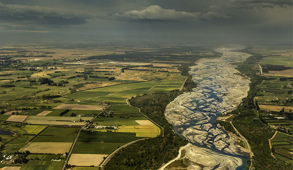
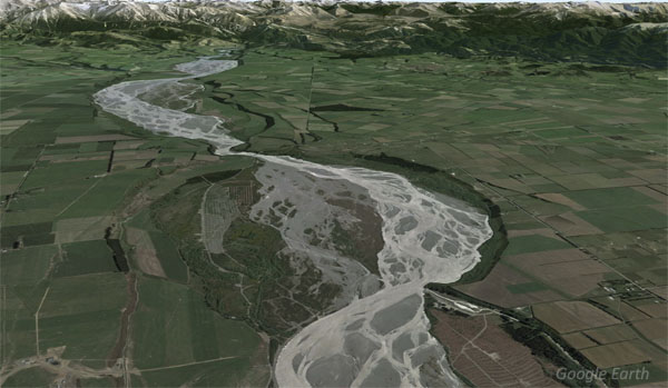
Regionally recognised as an outstanding natural landscape feature, the Waimakariri River’s headwaters are in the heart of the main divide of Southern Alps. With a catchment of some 2,500 km2 (click to see interactive map) around 90% of the river’s water originates above the spectacular 25km long Waimakariri Gorge. Once it leaves the gorge and fans out onto the Canterbury Plains, the river loses some of its groundwater to the gravelly soils, particularly around West Melton/ Christchurch, however it gains groundwater from the Waimakariri District around the Main North Road (SH1) bridge.
Under the Canterbury Water Management Strategy, the Waimakariri River is managed under 3 separate Zones: Selwyn above the gorge; Waimakariri below the gorge on the Canterbury Plains on the north side of the river and Christchurch-West Melton on the south side of the river.
While the upper reaches of the river are wild, as it crosses the Canterbury Plains the river has been straightened and stop-banked to prevent historic flooding, particularly of Christchurch. Nevertheless, it has maintained its braided characteristics in the lower reaches until it becomes constricted as it passes the SH1 motorway bridge before discharging into Pegasus Bay.
Water flow
Because of its origins on the heart of the Alps, the flow regime of the river is heavily dependent on seasonal changes in rainfall and snow. Climate change is often referred to as ‘risk multiplier’. Here in the Waimakariri, climate change is projected to alter this dynamic flow regime, with less winter snow pack in the upper catchment, and more winter and early spring rainfall. This is likely to lead to higher than normal freshes and floods as well as longer and more extreme periods of low flows.
Under the Waimakariri River Regional Plan, 10.5 cumecs of water is taken from the Waimakariri River for irrigation.
- River Report 24-hour Infoline: river flows (updated twice daily), rainfall, sign up for text alerts
- Catchment map and monitored sites include scientific indicators for water quality (LAWA: Land Air Water Aotearoa – Ashburton-Hakatere)
Biodiversity & Cultural Significance
Regarded as a significant source of mahinga kai, the Waimakariri River provided traditional access to mahinga kai resources in and around the high country lakes and the West Coast. Many of those trails are now roads through some of the most spectacular scenery in New Zealand.
Important Bird Areas on the Waimakariri River (7-page PDF) includes maps, habitat types, and threats relevant to the larger Rakaia catchment. This document was extracted from Forest & Bird’s 177-page 20Mb file on all rivers, lakes, and coastal areas.
Conservation activities
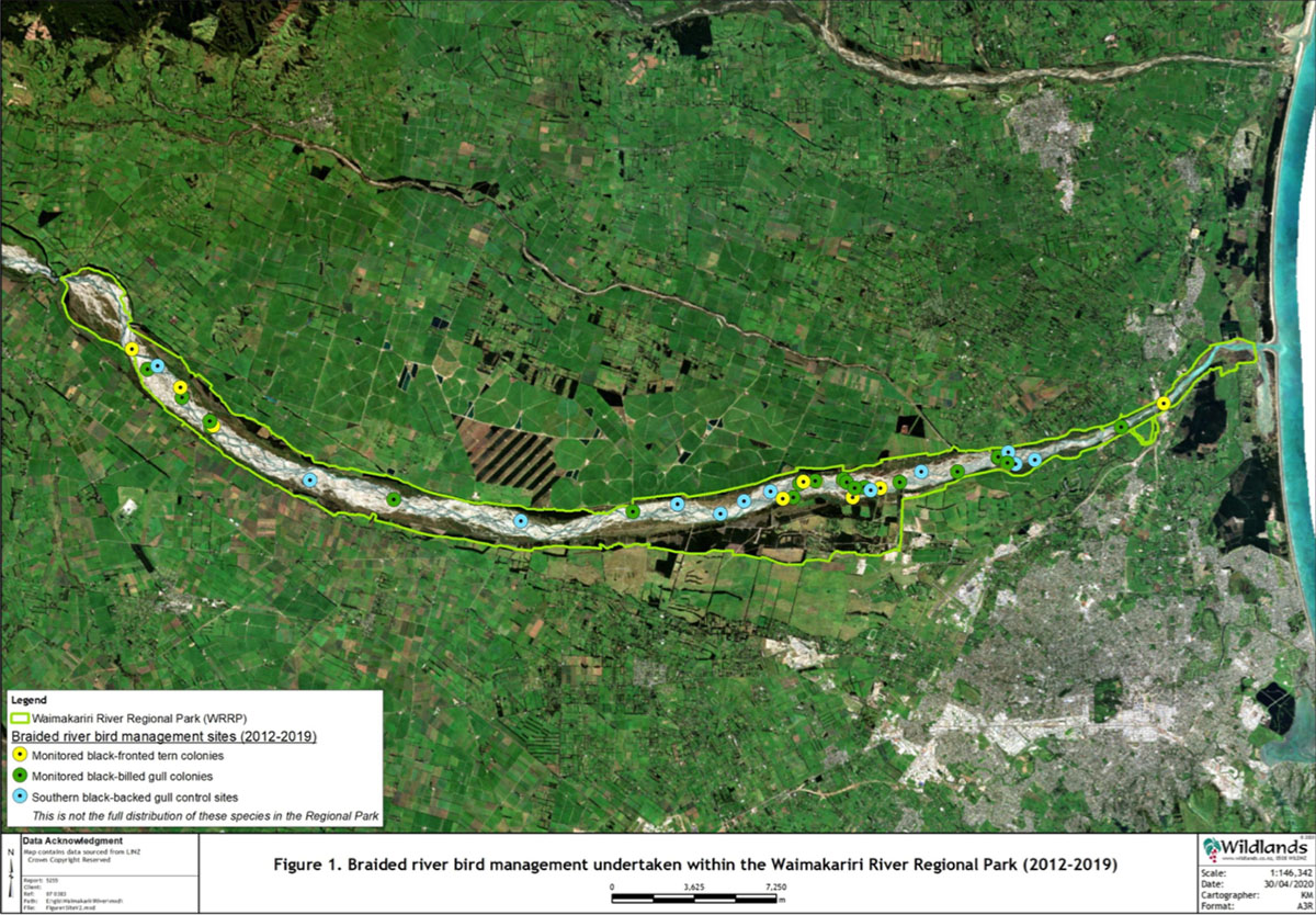
Extract from: Braided river bird management plan for the Waimakariri River Regional Park (45-page PDF)
The Waimakariri River Regional Park (the Regional Park, image above) covers 15,000 hectares of the Waimakariri River and riparian land that is managed by Environment Canterbury for flood protection and recreation. The Regional Park extends from Sheffield to the river mouth, near Kaiapoi. The lower Waimakariri River, from the Gorge to the mouth, is an important breeding and nesting habitat for various Threatened and At Risk indigenous braided river birds, i.e. species that rely on this habitat type for key elements of their life cycles.
To date, management of braided river birds in the Regional Park has been undertaken by the Environment Canterbury Parks Team. They require a management plan to help ensure the coordination, continuity, sustainability, and success of future management actions aimed at the protection and enhancement of the braided river bird populations.
Environment Canterbury’s work has focussed on the colony-nesting species – such black-billed gull (Larus bulleri) and black-fronted tern (Chlidonias albostriatus) – which are therefore the main focus of this review and management plan. These species have been the focus because there has not been sufficient resources to monitor and manage more widely dispersed species. Discussion is provided throughout the plan, however, on the need to include other endemic bird species in future monitoring and management.
Bird surveys & predator control: lower Waimakariri
- 2026: ECan Braided Rivers Conference Presentation: Waimakariri River Birds
- 2025-2026 Waimakariri Black-billed Gull Monitoring Season Report (Keystone Ecology)
- 2026: Review of Bird Monitoring undertaken on the Mid Waimakariri River. Contract report to Environment Canterbury (Toroa Consulting)
- 2024: Waimakariri River control and monitoring plan for Karoro/Southern Black-backed Gull (Toroa Consulting)
- 2023-2024: Lower Waimakariri River Southern Black Backed Gull Control An Operational Review of the 2023 – 2024 Season (ECan)
- 2022: Lower Waimakariri River pest mammal control plan (WMIL)
- 2021-2022 Braided River Bird Breeding Report (ECan)
- 2020-2021 Braided River Bird Management Report (ECan)
- 2019-2020 Braided River Bird Breeding Report (ECan)
- 2018-2019 Waimakariri River Regional Park (ECan)
- 2018 Waimakariri from Gorge Bridge to SH1 (Nov.) (ECan)
- 2018 Waimakariri-Kowai confluence (Nov.) (BRaid)
- 2017-2018 Waimakariri River Regional Park (ECan)
- 2016-2017 Waimakariri River Regional Park (ECan)
- 2015-2016 Waimakariri River Regional Park (Keystone Ecology / ECan)
- 2014-2015 Waimakariri River Regional Park (ECan)
Bird surveys & weed control: upper Waimakariri
2026: ECan Braided Rivers Conference Presentation: Waimakariri River Birds
Bird surveys
- 2020 Mid Waimakariri (ECan xls spreadsheet/ raw data)
- 2016 Upper Waimakariri (BRaid)
- 2014 Upper Waimakariri (full report)
- 2012 Upper Waimakariri (full report)
- 1981-2014 Upper Waimakariri (summary data)
Weed management plan
- 2023: Environment Canterbury Weed Control Summary 2022-2023
- 2022: Boffa Miskell; Upper Waimakariri Weed Control Control Strategy Full report | Strategy Report only | Appendices only
- 2014 Upper Waimakariri Weed Action Plan (DOC)
References & research material
- ECan document library: enter ‘Waimakariri River’ in the ‘keywords’ search field at the top of this page
- The river is administered by 3 separate zones:
- Selwyn above the gorge
- Waimakariri below the gorge on the north side of the river
- Christchurch-West Melton below the gorge on the south side of the river
- DOC catalogue of scientific publications: enter the relevant search terms in the ‘search’ dialogue box. You may need to vary your search, for example ‘black stilt’ gives far more results than ‘kaki’ or ‘kakī’
- See Rivers for a more comprehesive list of braided rivers research and reference material