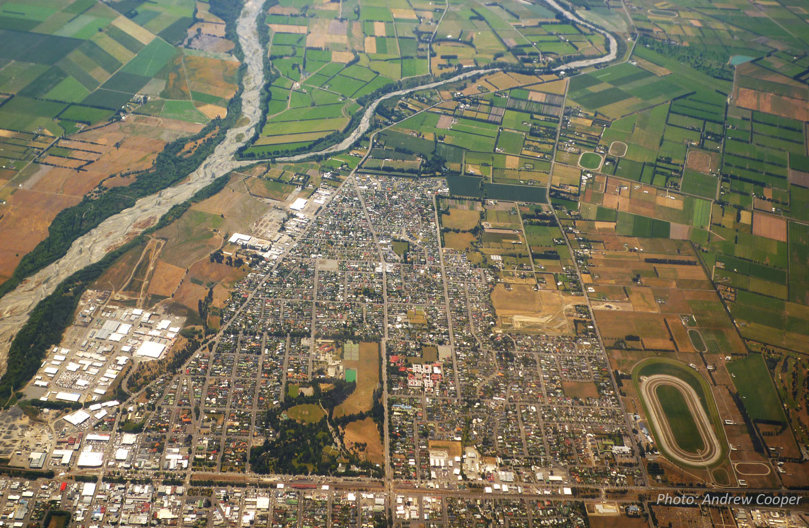
Ashburton-Hakatere River
The Ashburton River – Hakatere (Māori) (interactive catchment map) begins its 112km journey to the Pacific in two branches. The north branch drains the 2100m high Winterslow, Old Man, and Mt Hutt ranges at the base of the Southern Alps between the Canterbury Plains and the Lake Heron depression. The south branch drains the southern end of the Arrowsmith Range, crosses the south end of the Lake Heron depression, and skirts the south end of the Winterslow Range before reaching the Canterbury Plains at Mount Somers. From here, the two branches flow parallel just a few kilometres apart, down the lower-lying junction of the major fans of the Rakaia and Rangitata rivers before merging just upstream of the town of Ashburton, 21km from the coast.
May 2021 flood (before & after aerial images) and river flow data
- 6.168 cumecs at 11pm Friday 28 May
- 21.962 cumecs at 11pm Saturday 29 May
- 1,515.139 cumecs at 11pm Sunday 30 May
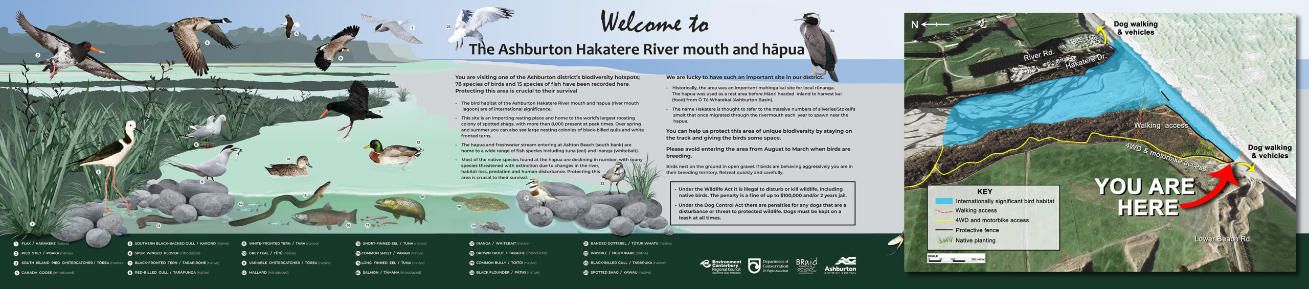
Biodiversity & Cultural Significance
Extract from the Ashburton Zone Implementation Programme ‘A large variety of native plants, birds and other species live in the rivers, lakes, wetlands, hapua and streams of our zone. Our zone’s braided rivers and lakes together provide the largest habitat (over 70,000 ha) for aquatic birdlife in NZ. Some 40,000 birds can be present at any one time.
The Hakatere/Ashburton River catchment supports about 14 native fish including threatened Canterbury mudfish, and threatened invertebrate species, such as the koura. About 48 native bird species live here. Four are nationally threatened and two are at-risk bird species. These include wrybill, banded dotterel, pied stilt, and black-billed gull.
For Ngāi Tahu, water is a taonga (treasure) left by the ancestors to provide and sustain life. All the waterways and their associated tributaries, wetlands and springs in the zone are considered significant resources, of cultural, spiritual and historical importance to Ngāi Tāhu.’
Important Bird Areas on the Ashburton – links to 6-page PDF file that includes maps, habitat types, and threats relevant to this river. This document was extracted from Forest & Bird’s 177-page 20Mb file on all rivers, lakes, and coastal areas.
Water flow
The river flow regime in the Ashburton River – Hakatere is diverse and typical of glacial fed rivers in the Canterbury region. Its main source of flow is from precipitation and snowmelt in the headwaters with the lowest flows occurring during the late summer, and the highest during springtime.
- River Report 24-hour Infoline: river flows (updated twice daily), rainfall, sign up for text alerts
- Lake Heron (Hakatere Conservation Park) (DOC)
- Catchment map and monitored sites include scientific indicators for water quality (LAWA: Land Air Water Aotearoa – Ashburton-Hakatere)

Conservation activities
- 2026: Bird Island Annual Report (ECan)
- 2024: South Ashburton-Hakatere outcome monitoring report 2023-2024
- 2023: Ashburton River Hakatere Shorebird Habitat Management Strategy 2023-2030
- 2022: Operational management plan for the enhancement of avifauna habitat at three sites in the lower Hakatere/Ashburton River (Wildlands Cons. for ECan)
- 2019: Management Plan in Action (ECan PPT seminar presentation June)
- 2019: Ashburton / Hakatere River Mouth Management strategy (PDF)
- 2016: Ashburton River/Hakatere shorebird habitat management plan
Bird counts & surveys
Queries? Please contact: Jean.Jack@ecan.govt.nz
- See Canterbury Maps braided river bird database for surveys | see here for a user guide
- River mouth bird monitoring data 2017 to 2025 (xls spreadhseet with raw data)
- April 2024 – March 2025: Ashburton Rivermouth Bird Monitoring (PDF)
- Upper Haketere Ashurton River Annual Bird Survey 2024
- Lower Hakatere Ashburton River Annual Bird Survey 2024
- Upper Hakatere Ashburton River Annual Bird Survey 2023
- Lower Hakatere Ashburton River Annual Bird Survey 2023
- April 2021 – March 2022 Ashburton Rivermouth Bird Monitoring (PDF)
- April 2020- March 2021 Ashburton Rivermouth Bird Monitoring (full report)
- Sept. 2020: North Ashburton, Digbys Bridge (pre-works survey)
- Oct. 2020: North Ashburton, Digbys Bridge (pre-works survey)
- Sept. 2020: South Ashburton – Walkhams Road (pre-works survey)
- 2019 Lower Ashburton survey (ECan)
- 2016-2017 Lower Ashburton Riverbird Monitoring: Summary Report
- 2016 River mouth survey (PDF)
- 1991-2015 (Xls summary)
References & research
- 2023: Local movements of Karoro/Southern black- backed gull (Larus dominicanus) on the lower Hakatere/Ashburton River
- 2017: Super-colony of some 10,000 birds nesting under a bridge on SH1 (see the video above for the location)
- 2014-15: Summary of events of gull colony at SH1 bridge
- 1992: (DOC) Birdlife of the Ashburton River
- See Rivers for a more comprehensive list of braided rivers research and reference material
- ECan document library: enter ‘Ashburton River’ in the ‘keywords‘ search field
- DOC catalogue of scientific publications: enter the relevant search terms in the ‘search’ dialogue box. You may need to vary your search, for example ‘black stilt’ gives far more results than ‘kaki’ or ‘kakī’