Rakaia River
One of the largest braided rivers in New Zealand with an average flow of 203 cumecs, the Rakaia River a catchment area (click to see interactive map) of approximately 2,900 km2. Its main tributaries are the Mathias, Wilberforce and Harper Rivers, which extend the catchment to the north-west and north respectively.
Because the Rakaia River’s headwaters are glacially fed in the Southern Alps and exposed to north-west rainfall, the river regularly floods during spring and early summer, even when the Canterbury Plains is experiencing drought conditions.
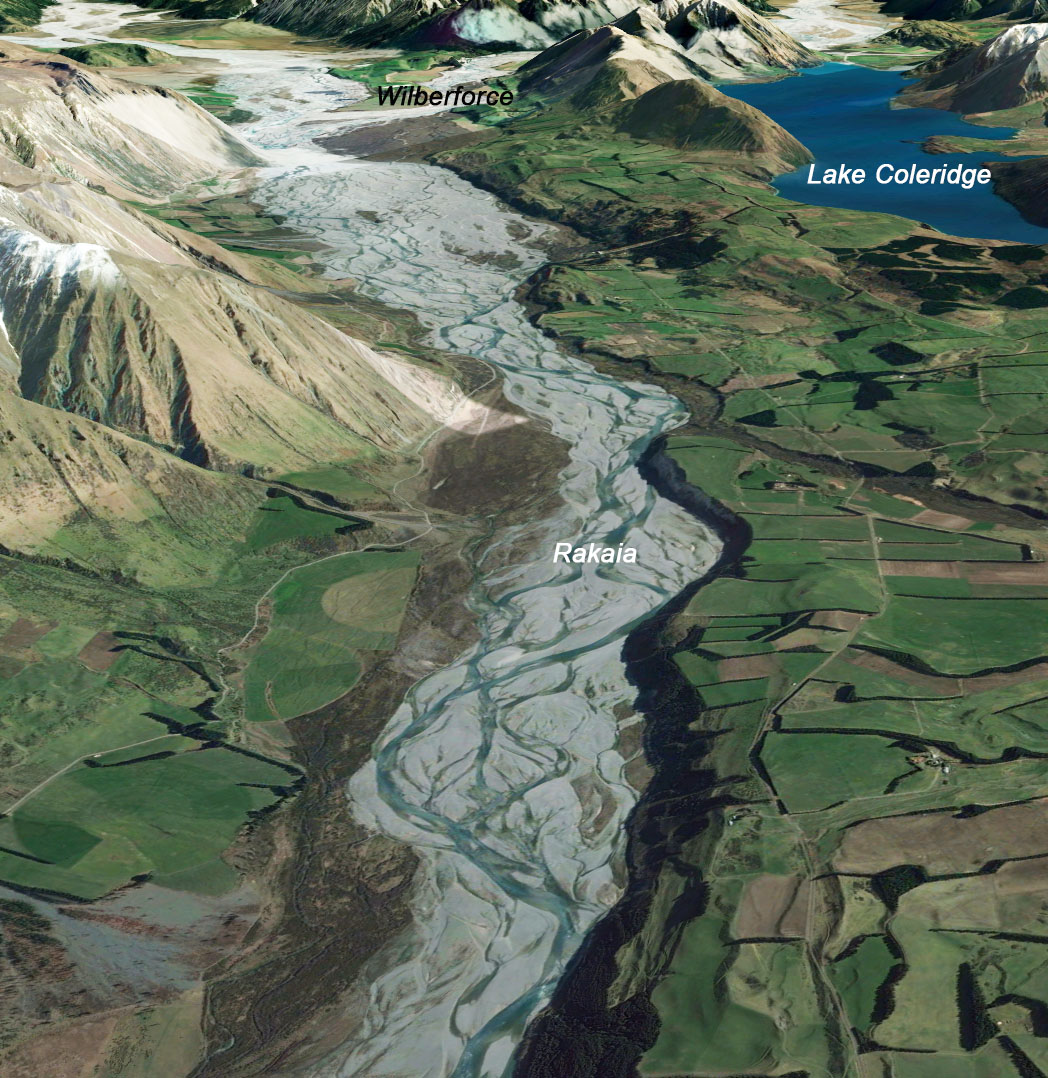
This has made the Rakaia an appealing water resource, with both Selwyn and Ashburton District Councils taking water for stock. Water is also diverted into Lake Coleridge from the Wilberforce and Harper Rivers for the Lake Coleridge Hydro Scheme.
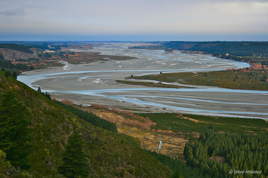
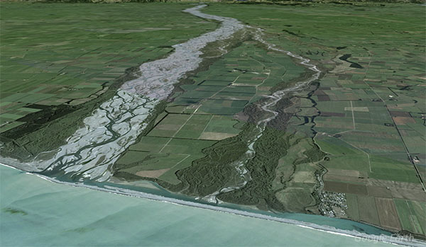
Downstream from Rakaia Gorge, as the river reaches the Canterbury Plains, water is allocated for irrigation. The average number of braids increases from 10 near the Rakaia Gorge to approximately 20 near the coast, some 64km south-east from the gorge. As it nears the coast, the river widens to more than 2km before discharging into the Pacific Ocean some 50km south-west of Christchurch and 13km south-west of Te Waihora (Lake Ellesmere).
Biodiversity & cultural significance
Extract from Selwyn Waihora Zone Implementation Plan (page 8): The Rakaia River ‘has significant cultural value for Ngāi Tahu as part of a trail to the West Coast and also for mahinga kai. The upper Rakaia area has an extensive intact and ecologically well-connected network of nationally significant wetlands, high country lakes, intermontane streams and braided riverbeds. It contains some of the largest intact wetlands in the region, including habitat for native fish and populations of native water birds. The river also supports rare riverbed species such as wrybill (around 73% of the known population of wrybill), black-fronted tern and banded dotterel.’
Important Bird Areas (IBAs): This is a 7 page extract from Forest & Bird’s 177-page Important Areas for New Zealand Seabirds. This extract includes maps, types of birds, habitats, and threats for birds in the Rakaia River and larger Rakaia catchment.
Hakatere Conservation Park , which straddles sections of the upper Rakaia and Rangitata Rivers, is part of one of the best wetlands in the country. A national wetland restoration project was started in 1997 and involves three premier sites: Whangamarino in Waikato, Awarua/Waituna in Southland and Ō Tū Wharekai here in Canterbury. The rivers, lakes, tarns and swamps of Ō Tū Wharekai have their own special range of species; some of which are rare, for example our kettle holes are home to 23 threatened plants. Although each wetland habitat is unique, all waterways are interconnected, breathing life into the Hakatere basin.
Conservation activities
The Rakaia River is one of ECan’s flagship programmes. The Implementation Strategy for the Braided River Flagship Programme – Upper Rakaia and Rangitata Rivers (2011), outlines the initiatives for both rivers, including specifically for the Upper Rakaia.
- 2024: Rakaia River Black Back Gull Control (Dec. 2023)
- 2023: Upper Rakaia Weed Strategy
- 2020: Upper Rakaia Trapping Report
- 2019: Presentation at the Braided Rivers Seminar on details and current outcomes of the project
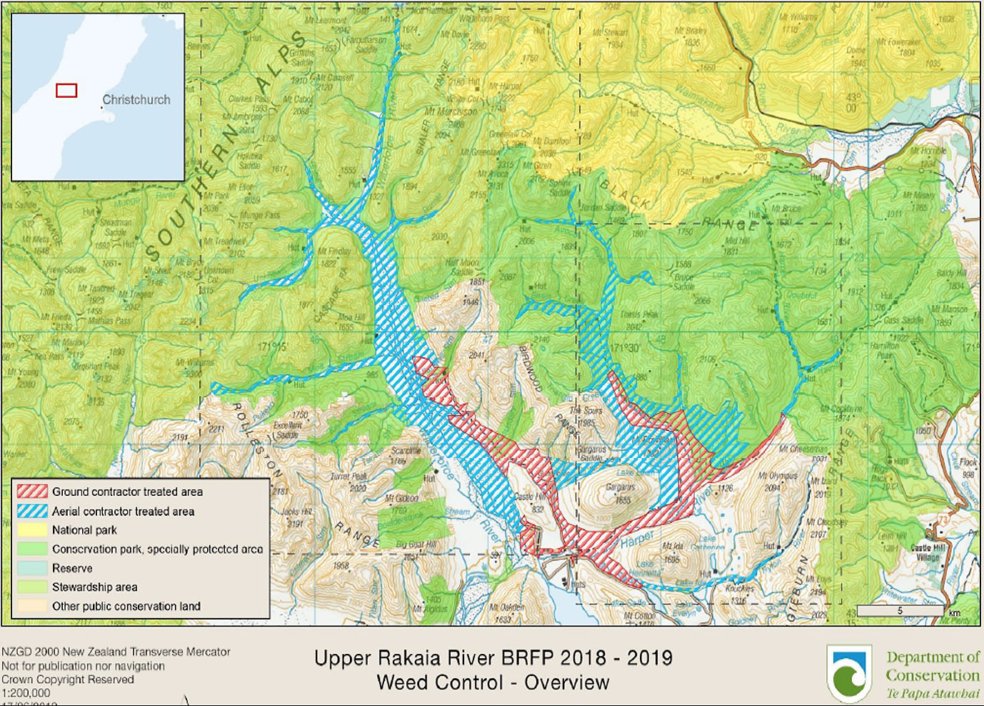
- 2018: Rakaia River Weed Control Strategy 5-Year Review (30Mb PDF – see the maps below showing the work carried out 2017-2019)
- 2013: Upper Rakaia Riverbed Weed Control Strategy
The Whitcombe Landcare Group is working closely with the DOC, LINZ, and ECan to stop the spread above the gorge road of wilding pines, elderberry, willow, blackberry, sycamore, Russell lupins and cotoneaster.
In 2018, the Department of Conservation began running an intense trapping programme in the upper Rakaia near Lake Coleridge village, to support the overall strategy to enhance braided river breeding habitats.


Water flow
- River Report 24-hour Infoline: river flows (updated twice daily), rainfall, sign up for text alerts
- Catchment map and monitored sites include scientific indicators for water quality (LAWA: Rakaia River)
Bird surveys
- October 2020: pre-works survey Griggs Road
- November 2020: pre-works survey Griggs Road
Additional references & research material
- 2024: Downer; Rakaia River Black Back Gull Control Project Summary – December 2023
- 2022: Bell & McCool; Rakaia River Black-fronted tern monitoring 2021-2022, report for Boffa Miskell.
- 2022: Khan; Comparing aerial image analysis and ground-level monitoring of weed control strategies for Rakaia and Clarence River, report prepared for Environment Canterbury
- 2014: (ECan) Indigenous insect fauna and vegetation of Rakaia Island
- 2011: (ECan) Implementation Strategy for the Braided River Flagship Programme – Upper Rakaia and Rangitata Rivers
- ECan document library: enter ‘Rakaia River’ in the ‘keywords‘ search field
- DOC catalogue of scientific publications: enter the relevant search terms in the ‘search’ dialogue box. You may need to vary your search, for example ‘black stilt’ gives far more results than ‘kaki’ or ‘kakī’
- See Rivers for a more comprehesive list of braided rivers research and reference material