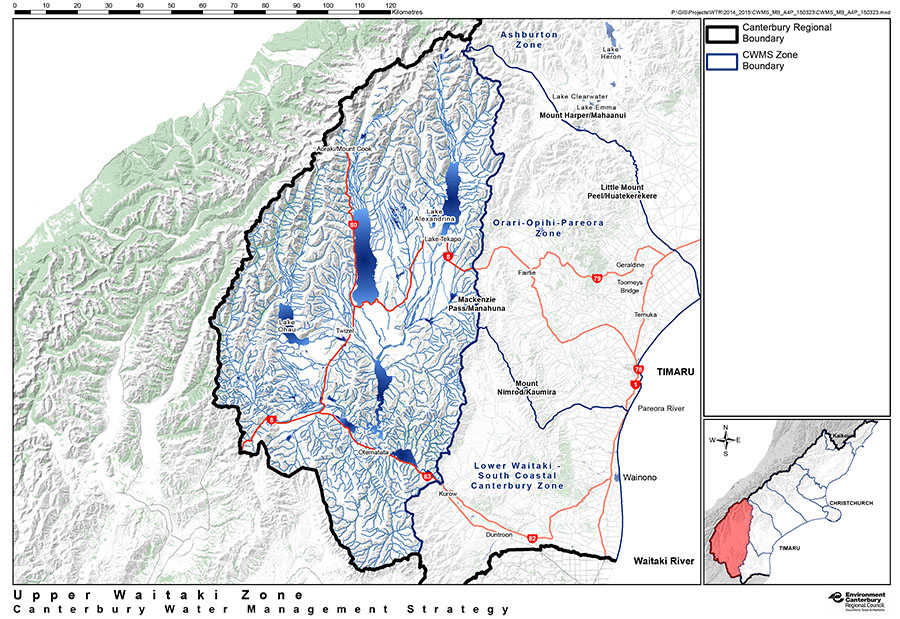
Upper Waitaki River
The Upper Waitaki, which includes the Mackenzie Basin catchment and Tasman River, covers 96,579km and is the single largest area monitored by Environment Canterbury.
It contains a network of small spring-fed streams, large gravel braided rivers fed from snowmelt and glaciers, an extensive hydroelectric scheme of canals and lake outlet dams, and large lakes that are mainly managed for power generation.
The catchment is of national importance for hydro-power generation and security of supply, contributing nearly 20% of New Zealand’s annual electricity requirements.
Biodiversity & cultural significance
Extract from the Upper Waitaki Zone Implementation Programme (page 6-7): ‘The environment is characterised by climate extremes of cold, heat, drought, frost, snow and high winds with a striking climate gradient where rainfall measured in metres about Aoraki Mt Cook drops to less than 400 mm/annum at the head of Lake Benmore; a distance of only 80km.
The resulting extremes and isolation have produced a distinctive indigenous flora and fauna characterised by slow growing stress tolerant species…
During glacial periods, rivers spilled out of the Tekapo, Pukaki, Ohau and Ahuriri catchments to deposit large amounts of gravel and silt. The processes of geological uplift, erosion and alluvial transport continue to maintain our braided river and associated wetlands today. The braided rivers: Hopkins, Dobson, Godley, MacCauley, Tasman, Tekapo, Pukaki Forks, Cass and Ahuriri, are highly valued and are regionally significant and distinctive, with wide shingle beds, snaking water channels and highly variable flows. They provide a unique habitat for several of New Zealand’s endangered wildlife species…
The ability to gather and share food and manaaki visitors is a cornerstone of Tangata Whenua society tradition and mana and is reliant on water that is fit for human consumption and able to support mahinga kai species as well as a healthy ecosystem. The Upper Waitaki is one of the migration routes to the West Coast and has been known as the kite kai (food basket) of the Central South Island…
Important Bird Areas on the Waitaki River: 7-page PDF file that includes maps, habitat types, and threats relevant to this river. This document was extracted from Forest & Bird’s 177-page 20Mb file on all rivers, lakes, and coastal areas.
Water flow
- River Report 24-hour Infoline: river flows (updated twice daily), rainfall, sign up for text alerts
- Catchment map and monitored sites include scientific indicators for water quality (LAWA: Upper and Lower Waitaki Catchment)
Conservation activities
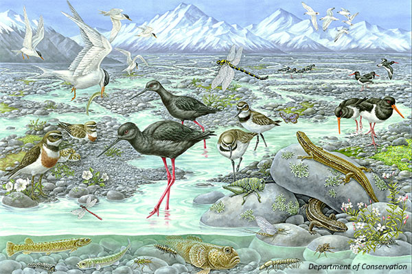
- Te Manahuna Aoraki is a large-scale conservation project focused on restoring the iconic natural landscapes and threatened species of the upper Mackenzie Basin and Aoraki National Park. Launched in November 2018, the project will enhance biodiversity across 310,000 hectares of New Zealand’s most stunning landscapes, including braided river systems, alpine habitats and Aoraki/Mount Cook National Park. The area is home to many endangered species like kea, rock wren and the scree weta in the alpine zone and braided river species like wrybill, robust grasshopper, banded dotterel, and the world’s rarest wading bird, kakī/black stilt.
- Project River Recovery and theKakī recovery programme are working together to test a catchment-wide predator trapping regime in the Tasman River. This project involves a range of predator control and monitoring techniques.
- Project River Recovery Annual Report 2021-2022
- August 2019 video of the latest release of captive-bred kakī/black stilt into the Godley River, one of the key tributaries in the Upper Waitaki
- Tasman predator control project
- 2017: Update on Kaki Programme
- 2017: Outcomes Predator Control Project
References & research material
- 2027: Braided Rivers Conference: All the diversity that you haven’t seen yet in the Upper Waitaki Basin
- 2016: Rebergen; Project River Recovery: after 25 years, what has or hasn’t changed? (BRaid workshop)
- DOC River Life – 26-page PDF on the ecology and geological history of the Mackenzie basin
- DOC website: native plants of the Upper Waitaki Basin
- DOC website: native animals of the Upper Waitaki Basin
- DOC Project River Recovery: 12-page bibliography of all reports, theses, diplomas, Department of Conservation publications and scientific papers produced or supported by the Project 1991-2007
- DOC catalogue of scientific publications: enter the relevant search terms in the ‘search’ dialogue box. You may need to vary your search, for example ‘black stilt’ gives far more results than ‘kaki’ or ‘kakī’
- ECan document library: enter ‘Tasman River’ in the ‘keywords’ search field at the top of this page
- See Rivers for a more comprehensive list of braided rivers research and reference material