Braidplains : habitat loss
“Human activities (weeds, agriculture, river engineering, and built structures) have reduced the physical area of braided river ecosystems and damaged their hydrology. These historic activities and mismanagement should not now be viewed as a license to exploit these (often weed-infested) damaged spaces in order to increase or protect personal or corporate profit margins. Allowing marginal/ephemeral spaces on braided rivers to be available for agricultural or other development will continue an ever-increasing cycle of contraction until braided rivers as ecosystems vanish, systematically squeezed into becoming ‘normal’ rivers.” – BRaid’s response to the Bridge Project to define a braided river
Braided rivers are an iconic and highly valued feature of the Canterbury landscape. They are also globally rare landscapes known as a braidplains (explained below), and as such, New Zealand has a special responsibility to protect them and the plants and animals that evolved to live here and nowhere else on Earth.
But the historic attitude towards rivers as water sources to be exploited and hazards to be controlled, and the perception that the braidplains these rivers inhabit were ‘wastelands’ to be converted into ‘productive’ forestry and agriculture, has forced these once-mighty rivers into ever-narrowing confined spaces.
Ecosystem services
Hydraulically-connected to the main river channels are the springs, wetlands, and small streams on the braidplain that act as lungs and kidneys of braided rivers. The biodiversity they support provides life-giving ecosystem services. They filter water and provide healthy habitats for plants, animals, and people. And they provide clean and plentiful mahinga kai.
It’s only relatively recently that the lifegiving ecosystem services these rivers provided have been recognised. But they’re now badly compromised due to over-exploitation. To reverse that, one of the targets in the Canterbury Water Management Strategy (CWMS) is to ‘protect the natural character of braided rivers’ and to ‘reverse the decline in braided rivers bird habitats’. These ecosystems and characteristics can only exist within braidplains.
To meet these goals, along with other research the regional council, Environment Canterbury (ECan) commissioned a report that ultimately revealed an astonishing 11,630ha of formerly undeveloped or forested river margin (braidplain) had been converted to intensive agricultural use between 1990 and 2012.
The dynamic nature of braided rivers is to change, primarily laterally over time—what has been referred to as a ‘fourth dimension’. A defining feature of braided rivers is that during high water flows, their multiple channels often join into one single channel that fills the entire braidplain. In alpine areas the braidplain is confined to alpine valleys.
Defining a braidplain
On the plains, the braidplain is the area that has been occupied (indeed formed by) the active channels of the river at some time in the past—and this can be a very wide area (see the grey box below). When the water recedes, new channels may have migrated to different locations within the braidplain.
Thus, the braidplain is integral to the existence of braided rivers. Taking away braidplains kills braided rivers in the same way that taking away a kiwi’s habitat and placing it in a box would ultimately lead to the extinction of the species.
But the term ‘landscape’ and ‘natural character’ are not clearly defined under the Resource Management Act. Nor does the Act, which, as of 2025 is being revoked by the National-led Government define braided rivers and braidplains. Meanwhile, the High Court defines braided rivers in the same way that European rivers are defined: “...the space of land which the waters of the river cover at its fullest without overtopping its banks.”
This wildly inappropriate definition does not in any way describe the dynamic 4-dimensionality of braided rivers and the iconic braidplains they inhabit. Nor does it take into account the hydraulic connection between the active river channels, wetlands, and springs that inhabit the braidplain. And so the conversion of these globally rare ecosystems into agricultural lands continues and braided rivers head slowly towards extinction.
Riverbed, Floodplain or Braidplain: what's the difference? And why does it matter?
“To be effective, conservation efforts in glaciated mountain landscapes intended to benefit the widest variety of organisms need a paradigm shift that has gravel-bed rivers and their floodplains [ie, their braidplains] as the central focus and that prioritizes the maintenance or restoration of the intact structure and processes of these critically important systems throughout their length and breadth.”- Hauet et al, Gravel-bed river floodplains are the ecological nexus of glaciated mountain landscapes Science Advances 24 Jun 2016: 2/6
“In summary, river encroachment is the single largest known and quantified threat to braided rivers in Canterbury…. Given the potential ecological risks and considerable uncertainty posed by climate change, there is an increased need to better protect and buffer braided river ecosystems. In practice, this means reducing existing pressures, such as river encroachment, water quality degradation, and exotic plants and animals, to “provide space” for the new pressures associated with climate change on native species. On the ground, this might involve such activities as evaluating the placement of stopbanks, to provide more space for braidplain development, or removal of introduced salmonids from selected high-value native fish habitats.” – Rangitata River Catchment Conservation Values October 2019
The image at the top of the page shows the Hurunui River braidplain on the Amuri Plains (formed by the same processes as the Canterbury Plains) facing west to the foothills of the Southern Alps. This illustrates the difficulty in defining ‘braidplains’ on lowland plains. Scroll down for an explanation of the terms ‘braidplain’ and ‘floodplain’. To open this location in Google Earth download this kmz file and open it from within the Google Earth ap.
The images below of the Rangitata River were sourced from CanterburyMaps and partners and licensed for reuse under CC BY 4.0. The B&W image is from the 1950s showing the extent of the braidplain and river channels. The colour images are from 2019.
Riverbeds and floodplains
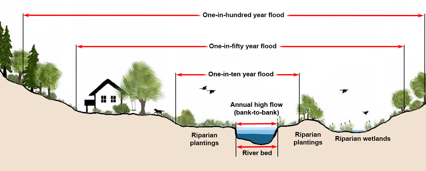
For planning and insurance purposes flooding is said to occur when a river over-tops its banks. Floodplains are defined as the area that a river is likely to flood. For example a ‘1-in-10-year’ floodplain is a given area likely to flood once every 10 years. But terms like ‘1-in-10’ or ‘1-in-100’ are statistical probabilities based on historical data. In any given year a ‘1-in-10’ year flood has a 10% chance of happening, while a ‘1-in-100’ year flood has a 1% chance of occurring.
Virtually all rivers in Europe have been (or are about to be) confined, channelled, redirected, harnessed for irrigation, water supply, and/or hydroelectricity production, and/or to prevent flooding.
When Europeans arrived in New Zealand, they regarded braided rivers in the same way as European rivers: resources to be exploited and potential hazards to control.
Braided river within a braidplain
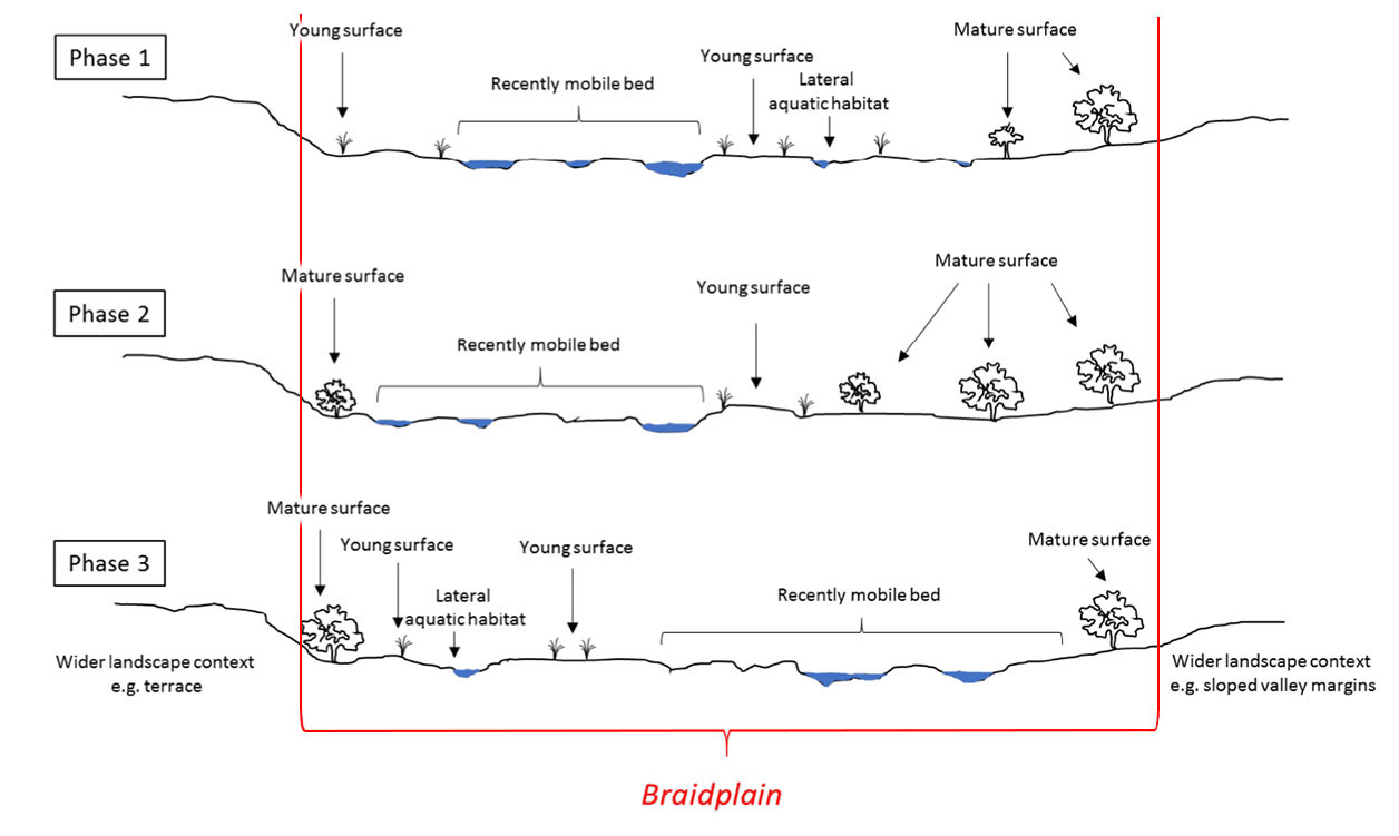
Illustration adapted from: NIWA Braidplain Delineation Methodology (Fig 1.1 p7)
Our braided rivers were formed when the glaciers that carved out the Southern Alps came and went over millions of years. When glaciers retreated during warmer periods* rivers reworked the gravelly glacial moraines left behind in the wide U-shaped valleys, creating temporary shingle islands separated by shallow interweaving channels or ‘braids’ across the valley.
Some three million years ago the Canterbury coastline was located much further inland at the foothills of the Southern Alps. Where the braided rivers flowed down out of the mountains, they deposited so much gravel that giant fan-shaped deltas formed along the ancient coastline. Over millions of years these deltas grew eastwards, spread out, and ultimately joined one another to become the lands we now call the Canterbury and Amuri Plains.
In a process that continues today, when heavy rain or spring snowmelt flows down these rivers the braids join, filling the valleys with fast-flowing water. When the water recedes it leaves behind a very different looking network of river braids and gravel islands.
This process is not a ‘flood’. It’s the very definition of a braided river’s dynamic behaviour. Its natural state is four-dimensional; that is, it’s not a waterway that generally stays confined within relatively stable banks over long periods of time. It’s a highly mobile system that rapidly changes the location and depth of its channels and islands over short periods of time.
*Interglacials: the current interglacial, the Holocene epoch, began ~11,500 years ago.
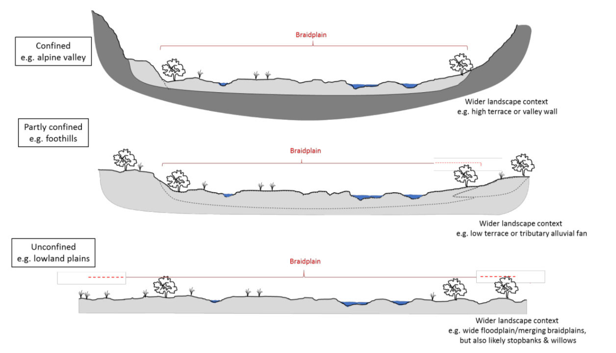
Not all braided rivers are the same. Defining ‘braidplains’ in the high country is relatively straightforward because they’re confined or partly confined by valleys formed by glaciers. But once the rivers leave the mountains and flow onto the Canterbury and Amuri Plains, they’re no longer confined. Instead, they wander across the plains. Working out exactly where a specific braidplain is for each river on the plains is much harder and may not, in fact, be possible in some cases.
The Waimakariri River for example, has historically moved back and forth between its current location, to south of the Banks Peninsular at Lake Ellesmere, and then back again. The city of Christchurch is located on the Waimkarariri ‘braidplain’ delta.
To protect Christchurch from floods the river has been confined by engineering works so that it now follows a much narrower ‘braidplain’. By the time the Waimakari reaches the ocean it’s confined to just one channel; there is no longer a braiplain at the river mouth.
While this confinement protects Christchurch from periodic river flooding, it also prevents the once-braided river from spreading sand and shingle across the coastal braidplain. Instead, much of that material now flows into the ocean. Waves still carry some sand and shingle onshore to the beaches, but not enough to keep pace with rising sea levels. Protecting coastal cities and towns like Kaipoi from river flooding has, perversely, helped compromise the coast’s natural defences against inundation from the sea.
Can we protect what remains?
Systematically forcing them into the solitary confinement of single channels is turning them into what University of Canterbury Professor James Brasington calls “zombie” rivers, waterways locked into position between stopbanks and their headwaters. Planting willows and poplars as a ‘natural’ way to hold them in place has just exacerbated the problem. Confining braided rivers not only creates problems for freshwater ecosystems including habitat for braided river birds, it also makes these rivers prone to catastrophic flooding.
“If we put our rivers into straight-jackets, they lose the diversity of form and process that are fundamental to the creation of thriving ecosystems. Instead, we should make space for rivers to erode their corridors, flood naturally in areas that are of less value which will in turn, reduce risks in more sensitive areas. We must work with natural processes to reduce the flood risk and support healthy river ecosystems.” –James Brasington
- Define the braidplain in geographic (geomorphological, hydrological, and ecological) terms:
- Consult with communities to determine what economic, social, environmental, and cultural values people place on braided rivers and braidplains.
The process is still in limbo.
Keynote address: Environment Canterbury Strategic Direction (PDF)
Cnr. Grant Edge: Environment Canterbury
Making room for rivers (PDF)
Tom Kay: Forest & Bird
Further information & references
Additional information
- New Zealand rivers carry a staggering 400 million tonnes of sediment from land to sea every year. Sediment yields from the Cropp River in the Southern Alps and Waiapu River near East Cape in the North Island are among the highest in the world. The Waiapu River, for instance, carries 35 million tonnes of sediment per year; the equivalent of a five-tonne truckload every 12 seconds.
- The Canterbury Plains are primarily reworked glacial outwash up to 3 million years old. Around 2 million years ago, Mt Horrible near Timaru erupted, pouring out a 5m thick layer of basalt over some 130 sq km of the plains.
- Section 6(e) of the Resource Management Act has provisions for “protection of the relationship of Maori and their culture and traditions with their ancestral land, water, sites, wahi tapu, and other taonga“. Maori regard braided rivers as taonga, and thus should be protected. But are braidplains ‘landscapes’? The Environment Court has suggested this definition: Landscape means the natural and physical attributes of land together with air and water which change over time and which is made known by people’s evolving perceptions and associations [such as beliefs, uses, values and relationships]”.
- Where braided rivers occur elsewhere in the world they are recognised as being largely ‘untamable’ and afforded different levels of protection.
- The Tragedy of the Commons (simple explanation of Hardin’s treatise)
References
- Resource Management Act 1991: currently being repealed (2025)
- (ECan) Canterbury Water Management Strategy | Natural Character of Braided Rivers
- NZ Civil Defence: defining ‘Critical Infrastructure’
- 2026: Braided Rivers Conference: Embracing the Braid – Evolution of Flood Protection in Canterbury (ECan presentation PDF)
- 2025: Newsroom: We strangled our rivers; now they’re fighting back
- 2025: McCabe et al; The ecological benefits of more room for rivers, Nature Water, 21 March (Open access): “Floodplain river ecosystems have been extensively artificially constrained globally. As climate change heightens flood risks, the command-and-control approach to river flood management is beginning to make way for a paradigm shift towards ‘living with water’.”
- 2025: Pompei: Monitoring the extent of braided river cover classes in Waitaha Canterbury – a 2012 and 2024 comparison, Environment Canterbury Science Summary R25/38 “…86,820 ha of braided riverbed was categorised as useable braided river bird nesting habitat for 2012. This increased to 119,070 ha in 2024.”
- 2024: Calkin; Land use change in and around Aotearoa New Zealand’s braided rivers, UC Masters Thesis
- 2023: Brower et al; New Zealand’s braided rivers: The land the law forgot Earth Surface Processes and Landforms 49 | 1 pp 10-14
- 2021: Greenep and Parker; Land use change on the margins of lowland Canterbury braided rivers, 2012-2019 (ECan report)
- 2021: Grove & Greenep; Land use change of braided river margins (presentation on the above to the Braided Rivers Seminar July 2021)
- 2021: Grove et al; Agricultural land use change in mid-Canterbury hill and high country, 1990- 2019: implications for indigenous biodiversity and ecosystem health (ECan report)
- 2021: Gray; Braided river ecosystems: physical habitat, ecological complexity and the management conundrum (presentation on the above to the Braided Rivers Seminar July 2021)
- 2021: Griffiths, Surman & Owen; Braided River Revival Whakahaumanu ngā awa ā pākahi and steering the river management ship, (Braided Rivers Seminar July 2021)
- 2021: Hoyle; Effects of flood harvesting on fine sediment deposition in braided rivers (Braided Rivers Seminar July 2021)
- 2021: Lanard; The Future Shape of Water, Water And Atmosphere, NIWA
- 2021: Davey; The plight of the foothills-fed Canterbury braided rivers (Braided Rivers Seminar July 2021)
- 2018: ECan; High country spring-fed streams: effects of adjacent land use
- 2018 (NIWA): Braidplain Delineation Methodology
- 2018 (ECan): Braided Rivers: Natural characteristics, threats, and approaches to better management
- 2017 (NIWA): Modelling vegetation-impacted morphodynamics in braided rivers
- 2017 (ECan): Shifting role of the Waimakariri River
- 2016 (DOC): Management and Research Priorities for New Zealand Braided Rivers
- 2016: Nagy; The Waimakariri River and its Environment: Frequency Analysis of Extreme Events and the Effects of Flow Modifications (Masters thesis)
- 2016: Hauer et al; Gravel-bed river floodplains are the ecological nexus of glaciated mountain landscapes Science Advances 24 Jun 2016: Vol. 2, no. 6, e1600026
- 2015: ECan; Land Use Change on the Margins of Lowland Canterbury Braided Rivers 1990-2012
- 2015: Latrubesse: Large rivers, megafans and other Quaternary avulsive fluvial systems: A potential “who’s who” in the geological record Earth-Science Reviews 146, July 2015 p1-30
- 2015 (Radio NZ): Democracy and Water Rights
- 2014: NIWA; Modelling channel dynamics in braided rivers
- 2011: Whitelaw; The vulnerability of Tuhaitara Coastal Park to Rising Sea-levels
- 2003 (NIWA): A bird’s eye assessment of gravel movement in large braided rivers
- (undated): Hearnshaw et al; Ecosystem Services Review of Water Storage Projects in Canterbury: The Opihi River Case